 |
 |
 |
 |
 |
 |
 |
 |
 |
 |
 |
 |
 Previous Page

032117_YKBP_A7.pdf

First Dakota National Bank

Winter Wheat Breaking Dormancy Early
Local Man Uses Modern Technology to Improve Crop Production
n
cent of
said.
utiny
ss-hedgercent
purd using
rice.
o come
ducers
ely
tor is
r
ghout
ty in
imes
tratek Risk
ison to
n said
aken
s on
cattle
sked
eight
o bias
d.
r a comoes not
e many
alf
achieve
und
the
of a
ce.
Broadcaster Press 7
March 21, 2017 www.broadcasteronline.com
National
Ag Week
Local Man Uses Modern Technology to Improve Crop Production
By Loretta Sorensen
Just about every yield advantage for
corn and soybeans has been identified,
except those that may only be observable
from an aerial point of view.
That potential for incrementally improving crop yield and quality is what motivates
Mission Hill farmer Chris Nelsen to make
use of drone technology.
After buying his first drone four years
ago, Nelsen has learned that a bird’s eye
view can reveal important information
about his crops and irrigation systems that
give him an advantage for his bottom line.
“Once a corn crop is four to five feet tall,
there are a lot of things you can’t see just
by looking across the field,” Nelsen says.
“You could have insects attacking the crop,
nutritional deficiencies in different areas of
the field or maybe some flooding problems. You won’t be able to address those
problems unless you have a way to identify
them. Drones can help wit that.”
Drone use in agriculture has evolved
as operators like Nelsen have learned how
to use them and drone technology has
advanced. What started as a quick way
to view a crop is now giving farmers an
opportunity to obtain GPS coordinates for
their entire field to create a map that can be
overlaid on a yield map to reveal a higher
degree of information about the crop.
“The Cadillac of drones starts uploading
data even as its flying over a field,” Nelsen
says. “There are third party vendors who
can take drone images and stitch them
together to create a panoramic view of the
crop. Add the geo reference data to that
and you have a lot of information about
your crop and your field.”
Infrared photography is one of the emerging features of drones used in agriculture.
Infrared photography can be used to help
assess a plant’s health. Traditionally, infrared
imagery for agricultural and ecological use
has been captured from satellites and airplanes. The information it provides has been
used mainly by large farming operations and
academic research projects.
However, farmers like Nelsen can now
use drones to capture infrared images of
crops and review the pictures to determine
if plants are suffering from issues such as
nitrogen deficiency or overwatering.
“Infrared images will provide a comparison of how ‘green’ each plant is,” Nelsen
says. “The greener the plant, the healthier
it is. Nitrogen deficiency is a common plant
health issue. However, something like a
plugged or worn irrigation sprinkler package
could be causing either excess or lack of water in an isolated area. Drones that capture
infrared images at any time the farmer needs
them can help in recognizing an issue and
responding to it as soon as possible.”
Infrared images of an operating irrigation sprinkler will reveal differences in the
concentric circles created by the water,
pinpointing an irrigation malfunction.
“In the past, we had to rely on satellites
to obtain these types of images,” Nelsen
says. “If it happens to be cloudy on the day
you need an image, you might have to wait
at least three or four days for that satellite
to pass over again. Drones can be launched
anytime there’s a need.”
Nelsen has found that ponding issues
that don’t appear to be too serious when observed from the ground level can look much
different from an aerial point of view. The
drone can reveal the length and breadth of
the ponding area as well as help in assessing
the health of plants in that area.
“If you use a $20,000 drone, you can have
video and images to review as soon as the
drone lands,” Nelsen says. “I don’t use one
with those features, but I am able to view
real time video on my phone or other digital
device by using a drone app. You can view
near infrared video, too.”
Farmers like Nelsen who have implemented drone technology in their operations are finding that they have a wealth of
data they don’t always know how to use.
Partnering with an agronomist or other
crop and soil specialists can help in mining
the information drones gather.
“You want to use that information to the
best of your ability to maximize efficiency and
productivity,” Nelsen says. “By putting the
trained eyes of specialists like an entomologist on your information you may discover
things you wouldn’t otherwise recognize.”
Nelsen cautions that use of drones
doesn’t relieve farmers of the need to physically scout their fields and get close to the
crop. All the images and video in the world
can’t replace that hands-on observation.
“You can’t just farm from the sky,”
Nelsen says. “You have to get out there. Just
flying over a field with a drone isn’t going to
make everything okay.”
To select an appropriate drone, Nelsen
ing them on his computer. Cloud storage is
recommends completing research to learn
usually an option for drone images. Nelsen
about the features of different types of
doesn’t rule out the use of other technolodrones and ask agricultural experts and
gies to maximize his potential for top yield
those engaged in the agriculture industry
production.
for their insight on the topic.
“This past year we used a plane
“There are companies who have all the
equipped with a high end camera to review
technical information and know all about
some drainage issues before we planted
designing and servicing a drone, but they
to avoid losing nutrients to runoff,” Nelsen
may not be able to help farmers undersays. “We can use the map generated
stand the benefits of stitching crop images
through that to overlay and correlate with
together or even help them find a vendor
our yield map to further identify any shortto provide that service,” Nelsen says. “Take
comings or faults in specific areas.”
time to weed out the drone companies that
Nelsen believes drone technology will conaren’t equipped to specifically help you
tinue gaining favor in the agriculture industry
make the most of your drone.”
because it extends the options for farmers to
The normalized difference vegetation index refine crop production and improve overall
(NDVI) is a simple graphical indicator that can
yield with data captured from the air.
be used to analyze remote sensing measure“Even a 2% or 3% loss is significant for
ments to assess whether or not the observed
farmers,” Nelsen says. “Losses can be reduced
target contains live green vegetation.
with tactics like fertilizer stabilizer to reduce
NDVI maps show the difference between leaching or drone data to reduce ponding.
the near-infrared (strongly reflected by veg- Incremental gains, especially in years with low
etation) and red light (which is absorbed
profitability, can make all the difference.”
by vegetation). The maps can be created by
drones that capture nearinfrared and red wavelength
data. The information aids
in activities like monitoring drought and predicting
yield. It also provides data
about density and intensity
of green vegetation growth.
Water stressed, diseased or
dead leaves become yellow
and reflect significantly less
in the near-infrared range.
“All this information can
be used to help develop
prescriptions for variable
rate planting, fertilizing and
irrigation,” Nelsen says.
“It could also be used to
develop spraying plans for
insect or weed treatments.
Based on the wave length
emitted, you could program
a sprayer to treat anything
that varied from the wave
length emitted by a corn
plant. All of that precision
matters in making crop
production affordable and
reliable.”
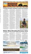
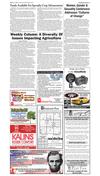
Mission Hill farmer Chris Nelsen uses modern farming
Nelsen has retained images technology, such as drones, to identify incremental
from the past four years, stor- improvements in his crop production that positively impact
his bottom line. Courtesy Photo by Loretta Sorensen
Winter Wheat Breaking Dormancy Early
Written collaboratively by Laura Edwards,
Adam Varenhorst, and Emmanuel Byamukama.
SDSU Extension
Historically Warm February
February 2017 will go down in the record
books as one of the warmest Februaries on
record, not just in South Dakota, but across
the United States. Some Eastern parts of
the state will end up more than ten degrees
above average for the month. The Western
region will end February around two to six
degrees above average.
As a result of these above average
temperatures, the abundant snow pack
that covered the state rapidly melted. As of
February 27, most of the state was snowfree except for the Southern tier counties.
Without snow cover to insulate the ground,
soil temperatures can warm quickly, and
winter wheat can break dormancy.
Winter Wheat Emergence: Threshold
Indicator
A threshold indicator for winter wheat
emergence is to consider average temperatures over a 14-day period. When that 14-day
average temperature is equal to or above
five degrees C, or 41° F, then hard red winter
wheat can break dormancy.
Historically in South Dakota, this threshold is met in the first week in April. Last
year, in 2016, winter wheat broke dormancy
in mid-March. This year, temperatures are
on track for an even earlier dormancy break
date, about a month earlier than average.
This is consistent with the winter wheat
growing region as a whole, in which many
areas have already broken dormancy a
month earlier than the historical average
date, and also earlier than last year. Some
warmer areas of the state, and warmer
areas of some fields, were seen to have
already broke dormancy the week of February 20th.
This is a potentially risky situation, as
historically there has been a 50% likelihood of a hard freeze (28° F) as late as May
1st-6th in most western and some central
counties. In addition to the frost/freeze risk
and winterkill, there are other potential
concerns regarding insect pests and disease
in winter wheat.
Insect Pests
During the spring of 2016 many insect
pests were observed in winter wheat fields
much earlier than anticipated. This was
attributed to the warmer temperatures that
led to winter wheat breaking dormancy in
mid-March. Insects are cold blooded organisms that rely on environmental temperatures to regulate many of their activities. In
addition, many insects that can be problematic in South Dakota overwinter in the
southern U.S. Warmer temperatures may
lead to earlier than normal flights.
The army cutworm is one insect pest
that was observed earlier than normal
during 2016. Army cutworm caterpillars
overwinter below the soil surface in winter
wheat fields. Once the soil
has sufficiently warmed up,
they become active and will begin feeding
on winter wheat. Due to the higher than
average temperatures it is possible that
the army cutworm populations may be
observed earlier than normal in 2017. Once
fields begin to break dormancy they should
be scouted for army cutworm populations.
Disease
Mild winter weather can lead to survival
of plant pathogens that normally would not
survive in South Dakota. Stripe rust is one disease of concern that can survive mild winters
in South Dakota. Stripe rust, which otherwise
develops from spores blown from Southern
states, has survived our winters in the last
two years. With winter wheat likely to break
dormancy early this year, this will increase
the likelihood of stripe rust to develop earlier
than normal. Winter wheat should be scouted
as soon as wheat greens up and an early
fungicide at herbicide timing planned if stripe
rust is observed.
FIRST DAKOTA
SALUTES
AGRICULTURE
PROUD TO SUPPORT OUR LOCAL PRODUCERS
Irrigation
Sales & Service
First Dakota National Bank salutes the families and businesses who work
hard every day supporting the Ag industry. Without you, we would not
have the land for a resource or be able to enjoy our quality of life.
Ag Week Open House - Friday, March 24
8:30AM - 12:00PM | Coffee and Pastries
First Dakota Conference Room
624-5555
1110 E Cherry Street :: Vermillion
FirstDakotaAg.com
Irrigation PVC, Wire Installed, Well Drilling Domestic & Irrigation Pump Installation
WATERLINE & ELECTRIC TRENCHING
Tree & Concrete Removal, Site Clearing,
& Ditch Trenching
ALL TYPES OF DIRT WORK - FREE ESTIMATES
Bobcats • Crane • Dozers • Excavators • Grader
Grain Trailer • Scrapers • Side Dumps • Trenchers
Vermillion, SD (605)670-9567
Hartington, NE (402)254-2568
Licensed in SD, NE & IA